On Saturday, I got up for a long run in the woods. Normally I would have joined the marathon training group in Portland, but we were on our annual vacation in Sunriver, so I decided to be disciplined and run on my own. While my compatriots were scheduled to do a seven-mile road run, I tried to map out an eight-mile run on forest trails along the Deschutes River.
After a lot of fuss (I can’t seem to get out the door for a run without a lot of fuss), I left the rental house at 6:15. Before I headed out, I posted the following on Twitter:
On a long weekend vacation. Off for a solo 8-mile run in the woods. My biggest fear? Being eaten by a bear. I’m bear-phobic.
I was only half joking. I’m always worried of bears.
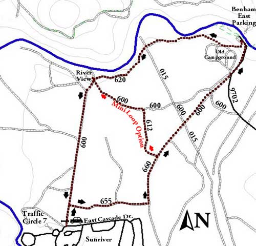
It was cold out. There was frost on the windshields of our cars. My breath was puffy. But I was bundled up against the elements, and knew that once I started running, things would be okay. I made my way along the paved roads to the beginning of the hiking path to Benham Falls. I had scrawled a rudimentary version of this Forest Service map to help me navigate the network of trails:

At first the run was difficult. Runs always seem to be difficult for the first ten or twenty minutes. The ground was a curious mix of too hard and too soft. Because it was below freezing, the dirt was crunchy. But the soil was also “airy”, with a lot of compression when I stepped on it. It was confusing &mdahs; my body was forced to make all sorts of micro-adjustments.
I followed my hand-drawn map along FS655 to FS600 and into the old campground. Everything was fine. I found the hiking trail along the river. But then things got a little hairy. There was snow on the ground. I continued along what I believed was the correct path, but found myself completely surrounded by a sea of white. There was not way to tell where I was or where I should be going. Yikes. I backtracked to a known landmark, and tried to figure out what to do. Eventually I found another path that seemed to go in the right direction and resumed my run.
I ran up the hillside and through the woods, occasionally having to deal with patches of old, crusty snow. (This stuff was icy, so I walked over it, and gingerly.) The brush along the side of the trail chewed up my ankles. I couldn’t really tell where I was.
Eventually I came to a long, wide straight path dominated by power lines. “This doesn’t look right,” I told myself. “I don’t think I’ve come far enough.” I pulled out my map. I couldn’t tell if this was the right place to head south or not, but neither did I have any better options. I couldn’t see that my current trail continued further. I followed the power lines south.
About ten minutes later, I encountered FS600 coming in from the side. “That’s strange,” I thought. “Aren’t I already on FS600?” I decided to have faith. I continued south on FS600. When it turned northeast, I continued to follow it. “Aha!” I thought. “This looks familiar.” I had run this path half an hour before. I now began to suspect that I’d taken the mini loop option marked on the map. (I was wrong, but I had the right idea.) But then I took a wrong turn and followed FS600 southeast to paved road 9702.
I was confused.
Ultimately I decided that I should just head north along the paved road, which I knew led to the campground. And it did. I followed the path up the hillside again and then southwest to the powerlines. When I went to pull out my map again, it wasn’t there. It had fallen out of my pocket. “Argh,” I thought. “I’m lost in the woods without my map.”
I wasn’t too worried, though. I knew that if I followed the Deschutes River west and south, I’d eventually come to parts of Sunriver that I knew. I was more concerned with continuing my run. Because I knew the powerline road had been wrong, I searched until I found another trail heading southwest. This trail led me to another confusing junction, but I was able to puzzle out the correct path, and then find my way back to the start.
I had run (and walked when confused) for ninety minutes. “I don’t think I’ve gone eight miles,” I thought. “Maybe I’ve gone five.” So I turned around and ran back the road I’d just travelled until I reached the river again. Then I ran home. It turns out my guess-work was about right.
When I returned to the rental house, I used MapMyRun to determine the distance I’d travelled. I had actually traveled 6-1/2 miles after ninety minutes. With my extra run to the river and back, I had brought the distance to 8.47 miles in one hour and 51 minutes.
Best of all? I hadn’t encountered any bears.

If someone had asked me a few months back if I thought JD could run two miles without stopping, I would have said no. So, seeing that you are now running nearly nine miles is pretty darn impressive! Congrats and keep up the good work, but be sure to take good care of yourself otherwise. The worrier in me fears an injury.
J.D., next time you’re in town, I’d be more than happy to lend you a spare gps. Actually I can sympathize with your phobia, mines with cougars though. Whenever I go for a hike, I just know that a cougar is going to make me his breakfast!